
Wiadomości
Zaadaptowane publikacje ze sprawdzonych zewnętrznych źródeł z tłumaczeniem, atrybucją i lokalizacją na trzy języki.
267 wiadomości w publicznym feedzie
20 wiadomości

Dane i statystyki
1 min czytania
NACE_R2_1 - "Updated code list"
Statistical classification of economic activities in the European Community (NACE Rev. 2.1)
Без рейтингу0 коментарів1 хв
Czytaj artykuł→
Dane i statystyki
1 min czytania
ANIMALS - "Updated code list"
Live animals
Без рейтингу0 коментарів1 хв
Czytaj artykuł→
Technologia
1 min czytania
AIRPOL - "Updated code list"
Air pollutants and greenhouse gases
Без рейтингу0 коментарів1 хв
Czytaj artykuł→
Dane i statystyki
1 min czytania
AGRIPROD - "Updated code list"
Agricultural products
Без рейтингу0 коментарів1 хв
Czytaj artykuł→
Przerwa na quiz
Zmęczony czytaniem? Rozwiąż quiz dnia
Dane i statystyki
1 min czytania
ESTD_EMIS - "New code list"
European emission standards
Без рейтингу0 коментарів1 хв
Czytaj artykuł→
Nauka i kosmos
2 min czytania
June 2026 Satellite Puzzler
Earth Observatory Earth Earth Observatory Image of the Day EO Explorer Topics All Topics Atmosphere Land Heat & Radiation Life on Earth Human Dimensions Natural Events Oceans Remote Sensing Technology Snow & Ice Water More Content Collections Global Maps World of Change Articles Earth Matters Blog Blue Marble: Next Generation EO Kids Mission: Biomes About About Us Subscribe 🛜 RSS Contact Us Search Every month, NASA Earth Observatory features a puzzling satellite image. The June 2026 puzzler appears above. Your Challenge I dentify the location shown in this satellite image. Share what clues you see, where you think it is, and what makes this place interesting or unique to you. How to Answer Submit your response using this form and select “Puzzler Answer” as the topic. Please include your preferred name or alias. You can keep it simple and just guess the location. Want to impress us? Tell us which satellite and instrument captured the image, which spectral bands were used, or point out a subtle detail about the geology or history of the area. If something catches your eye, or if this is your home or means something to you, we’d love to hear about it. The Prize We can’t offer prize money or a trip to space to see Earth like satellites and astronauts do . But we can offer something almost as rewarding: puzzler bragging rights. About a week after the challenge, we’ll post the answer at the top of this page, along with a link to an Earth Observatory Image of the Day story that explains the image in more detail. We’ll recognize the first person who correctly guesses the location, and we may also highlight readers who share especially thoughtful or interesting answers. By submitting a response, you acknowledge that your comments may be edited, excerpted, and published on this page. Until then, zoom in, look closely, and enjoy the challenge. See you at the reveal!
Без рейтингу0 коментарів2 хв
Czytaj artykuł→
Dane i statystyki
1 min czytania
HLTH_EHIS_VIU - "Dataset: updated structure"
Correction of vision problems by sex, age and degree of urbanisation
Без рейтингу0 коментарів1 хв
Czytaj artykuł→
Dane i statystyki
1 min czytania
HLTH_EHIS_VIE - "Dataset: updated structure"
Correction of vision problems by sex, age and educational attainment level
Без рейтингу0 коментарів1 хв
Czytaj artykuł→
Sprawdź się
Myślisz, że znasz odpowiedź? Rozwiąż szybki test
Nauka i kosmos
1 min czytania
HLTH_EHIS_UN1U - "Dataset: updated structure"
Self-reported unmet needs for health care by sex, age, specific reasons and degree of urbanisation
Без рейтингу0 коментарів1 хв
Czytaj artykuł→
Nauka i kosmos
1 min czytania
HLTH_EHIS_UN1E - "Dataset: updated structure"
Self-reported unmet needs for health care by sex, age, specific reasons and educational attainment level
Без рейтингу0 коментарів1 хв
Czytaj artykuł→
Nauka i kosmos
1 min czytania
HLTH_EHIS_UN1D - "Dataset: updated structure"
Self-reported unmet needs for health care by specific reasons, level of disability (activity limitation), sex and age
Без рейтингу0 коментарів1 хв
Czytaj artykuł→
Nauka i kosmos
4 min czytania
NASA Knows: What Is Mass Distribution?
4 Min Read NASA Knows: What Is Mass Distribution? This article is for students grades 5-8. Mass distribution affects everything from galaxy shapes to aircraft design to planetary rotation. It’s used to map stars in our universe, figure out what planets are made of, and even to determine how luggage is loaded onto an airplane. Mass distribution can be a tricky thing to understand. So, let’s explore it using an everyday example: a soccer ball. How Does Mass Distribution Affect Center of Mass? Have you ever kicked a soccer ball and wondered why it curves, spins, or sometimes wobbles? Mass distribution plays a part. On the outside, soccer balls look simple – a series of geometric shapes woven together in a pattern. But on the inside, they are carefully engineered. The key to a great soccer ball is something you can’t see: how the mass is distributed inside the ball. When engineers build a soccer ball, they try to make sure its mass is evenly balanced in all areas. This is because the way a ball spins and flies depends on how its mass is arranged. If one part of the ball is slightly heavier, its center of mass shifts. If the ball’s center of mass isn’t precisely balanced, the ball won’t move smoothly. ______________________________________________________________________ Words to Know mass: the measurement of the amount of matter in an object mass distribution: how mass is spread within an object center of mass: the unique point around which the mass of an object is perfectly balanced ______________________________________________________________________ How Is Mass Distribution Measured? Scientists and engineers use tools like precision scales, computer models, and repeated testing to determine an object’s mass distribution. These efforts help them design balanced airplanes, rockets, and even soccer balls. Their goal is to achieve dynamic balance, meaning the object can travel smoothly without unexpected movements. How Does Gravity Affect How We Study Mass Distribution? On Earth, gravity hides some of the details about how objects move. In microgravity, astronauts can observe motion more clearly. In 2019, Adidas partnered with NASA and sent soccer balls to the International Space Station. Astronauts conducted tests to help engineers confirm their designs and understand the physics behind ball motion in ways they simply can’t on Earth. The results of the space station experiments have already helped improve the accuracy and consistency of modern soccer balls. Try It Yourself You don’t need to go to space to explore the physics of a ball in motion. Try this experiment at home or school: Grab different types of sports balls (soccer ball, basketball, tennis ball) Spin each one on the ground or between your hands Watch for wobbling, flipping, or smooth spinning Can you tell which balls are well balanced? Or which ones might have uneven mass distribution? Career Corner Are you interested in a career that explores the science and engineering of mass distribution? Many different occupations can help you strike the perfect balance. Here are a few examples: Computer-Aided Design (CAD) Technician/Drafter: These specialists convert sketches and engineering designs into technical drawings. They use powerful computer software to create detailed 3D and 2D drawings of objects. A two-year associate degree from a technical or community college is key to this career path. Computational fluid dynamics engineer: These engineers use computer simulation tools to model and analyze fluid behavior in real-world situations. They might study airflow around sport ball designs or explore ways to improve aircraft wings. They need a strong background in engineering and the ability to analyze complex problems. Physicist: These scientists study matter and energy. They develop models and theories to explain how things work, conduct experiments, and use math to better understand the universe. A career in physics demands a strong understanding of math and complex problem-solving and usually requires an advanced college degree. More to Explore: The Science of Soccer in Space: Hands-on Activity From Orion’s Quest Aerodynamics of Soccer NASA Knows for Students Grades 5-8
Без рейтингу0 коментарів4 хв
Czytaj artykuł→
Wyzwanie
Rzuć sobie wyzwanie — test w zaledwie 2 minuty
Nauka i kosmos
5 min czytania
San Francisco’s Metropolitan Mosaic
Earth Observatory Science International Space Station (ISS) San Francisco’s Metropolitan… Earth Earth Observatory Image of the Day EO Explorer Topics All Topics Atmosphere Land Heat & Radiation Life on Earth Human Dimensions Natural Events Oceans Remote Sensing Technology Snow & Ice Water More Content Collections Global Maps World of Change Articles Earth Matters Blog Blue Marble: Next Generation EO Kids Mission: Biomes About About Us Subscribe 🛜 RSS Contact Us Search May 27, 2026 A period of unsettled weather brought scattered showers and thunderstorms to California’s Bay Area on May 27, 2026. That afternoon, a break in the clouds left downtown San Francisco and nearby communities beneath mostly cloud-free skies, allowing an astronaut aboard the International Space Station to take this photograph. The image captures two of the region’s iconic bridges. The Golden Gate Bridge connects the northern San Francisco Peninsula with Marin County to the north, while the San Francisco-Oakland Bay Bridge spans the bay toward Oakland to the east. Near the center of the image, Golden Gate Park stands out as a long, rectangular strip of green amid the dense urban landscape. Spanning more than 1,000 acres (400 hectares), the park encompasses meadows, gardens, wooded areas, and lakes. Additional green space toward the north around the Golden Gate Bridge is part of a national recreation area . The nadir (downward-looking) perspective also provides a clear view of the patchwork of street grids , which were laid out over San Francisco’s hilly terrain as the city grew in successive stages. In the heart of the downtown area, Market Street runs southwest to northeast and serves as a prominent divider between two distinct grid orientations: one aligned with the bay and the other aligned with the street. Along the northeastern and eastern waterfront, various structures extend into the bay. Toward the north, these include a historic wharf, seawalls, and piers—most built in the early 1900s, though some date back into the 1800s. The adjacent waters support heavy maritime traffic, including cargo and container ships, cruise vessels, and regional ferries. Breaking waves are visible along the western coast, including at Ocean Beach , the 3.5-mile stretch of sandy shore adjacent to Golden Gate Park. On May 27, the National Weather Service warned of hazardous conditions at the region’s beaches due to strong northerly winds. Long-period swells from the northwest contributed to the increased risk of rip currents as well as sneaker waves in the days after this image was acquired. Astronaut photograph ISS074-E-619284 was acquired on May 27, 2026, with a Nikon Z9 digital camera using a focal length of 800 millimeters. It is provided by the ISS Crew Earth Observations Facility and the Earth Science and Remote Sensing Unit at NASA Johnson Space Center. The image was taken by a member of the Expedition 74 crew . The image has been cropped and enhanced to improve contrast, and lens artifacts have been removed. The International Space Station Program supports the laboratory as part of the ISS National Lab to help astronauts take pictures of Earth that will be of the greatest value to scientists and the public, and to make those images freely available on the Internet. Additional images taken by astronauts and cosmonauts can be viewed at the NASA/JSC Gateway to Astronaut Photography of Earth . Story by Kathryn Hansen. Downloads May 27, 2026 JPEG (12.13 MB) References & Resources California State Parks, Port of San Francisco Embarcadero Historic District . Accessed June 8, 2026. National Park Service, Golden Gate National Recreation Area . Accessed June 8, 2026. NWS Bay Area via X (2026, May 27) Heading to the beach tomorrow? Accessed June 8, 2026. NWS Bay Area via X (2026, May 27) Radar Update: Showers with brief downpours and some isolated thunderstorms are winding down . Accessed June 8, 2026. NWS Bay Area via X (2026, May 26) The ocean is not your friend today and tomorrow! Accessed June 8, 2026. San Francisco Recreation & Parks, Discover Golden Gate Park . Accessed June 8, 2026. You may also be interested in: Stay up-to-date with the latest content from NASA as we explore the universe and discover more about our home planet. Belts of Green in the Washington Suburbs 3 min read Along the northeast side of the Capital Beltway in Maryland, green spaces weave through the developed landscape. Article Contours of the James Bay Lowlands 3 min read After the Laurentide Ice Sheet retreated from present-day Hudson Bay, rebounding land has revealed striking nearshore topography. Article Great Balls of Fire 4 min read An astronaut on the International Space Station was surprised to photograph a shower of light streaking through the darkness while… Article 1 2 3 4 Next Keep Exploring Discover More from NASA Earth Science Subscribe to Earth Observatory Newsletters Subscribe to the Earth Observatory and get the Earth in your inbox. Earth Observatory Image of the Day NASA’s Earth Observatory brings you the Earth, every day, with in-depth stories and stunning imagery. Explore Earth Science Earth Science Data Open access to NASA’s archive of Earth science data
Без рейтингу0 коментарів5 хв
Czytaj artykuł→
Nauka i kosmos
2 min czytania
NASA’s INCUS Satellites Progress Toward Launch
2 Min Read NASA’s INCUS Satellites Progress Toward Launch PIA26614 Credits: Blue Canyon Technologies Photojournal Navigation Science Photojournal NASA’s INCUS Satellites… Photojournal Home Photojournal Search Latest Content Galleries Feedback RSS About Downloads NASA’s INCUS Satellites Progress Toward Launch JPEG (10.32 MB) Description One of the three satellites that make up NASA’s INCUS (Investigation of Convective Updrafts) mission sits on a fixture at the facilities of Blue Canyon Technologies in Lafayette, Colorado. The satellite completed testing in preparation for launch in late May 2026. The mission will make the first space-based survey of the dynamics of tropical convective storms. The three nearly identical satellites will fly in tight coordination in low Earth orbit, with the first and second satellites separated by 30 seconds, and the second and third satellite separated by 90 seconds. Each satellites carries a radar designed to observe the vertical motion of air and water — known as convective mass flux — as storms develop and evolve. The middle satellite will also carry a microwave radiometer. The INCUS mission is set to launch in 2027 from NASA’s Wallops Flight Facility in Virginia. Funded through the Earth Venture Mission-3 acquisition under NASA’s Earth System Science Pathfinder Program and led by principal investigator Sue van den Heever at Colorado State University in Fort Collins, INCUS is one of several missions fulfilling the clouds, convection, and precipitation requirements of NASA’s Earth System Observatory, a set of interconnected missions set to study our home planet’s dynamic natural systems and how they interact. The mission is also part of FALCON (Fleet for the Atmosphere Linking Commercial Observations with NASA), a fleet of atmosphere-observing satellites that will combine hardware contributions from NASA centers, universities, and commercial partners. Keep Exploring Discover More Topics From Photojournal Photojournal Search Photojournal Photojournal’s Latest Content Feedback
Без рейтингу0 коментарів2 хв
Czytaj artykuł→
Nauka i kosmos
4 min czytania
How NASA Science and Artemis Are Shaping the 2026 FIFA World Cup
Researchers tested soccer balls aboard the International Space Station to study how internal mass affects motion and stability in microgravity. NASA As the FIFA World Cup approaches, NASA is bringing space science and engineering to soccer fans worldwide. From June 11 to July 19, 2026, NASA will host an exhibit at FIFA Fan Festival™ Houston where visitors can learn how research aboard the International Space Station benefits life on Earth and experience missions in low Earth orbit, the Moon, and beyond through the Artemis program. On June 11, as the FIFA World Cup begins, NASA’s exhibit at Fan Festival Houston will open to the public. The event is free to attend and open for every match of the tournament in East Downtown, Houston. On June 20, Johnson Space Center Director Vanessa Wyche will introduce select Artemis II crew members following their historic mission around the Moon. The crew will participate in World Cup activities ahead of the Netherlands-Sweden match in Houston and will appear on the Fan Festival Houston main stage to share their experience with fans. The connection between NASA and the World Cup goes beyond the exhibit floor, reaching all the way to orbit. NASA spinoff technologies are innovations developed for space exploration that go on to shape commercial products and everyday life – even on the soccer field. For more than 25 years, research aboard the International Space Station has enabled breakthroughs in science, technology, and human health while advancing innovations that benefit people on Earth. That work includes studies that improve understanding of the aerodynamics and physics involved in soccer ball flight. In partnership with the ISS National Laboratory in 2019, researchers used the station’s microgravity environment to study how a soccer ball’s internal mass affects its motion, stability, and rotation. The findings have improved understanding of how embedded technologies, including match-ball sensors, can influence performance during play. The research contributed to studies used in the development and evaluation of soccer balls for major international tournaments, including FIFA World Cup competition. Understanding the relationship between an object’s center of mass and its geometric center is key to predicting how free-flying objects move, including spacecraft, satellites, and aircraft. Since 2022, Adidas has embedded electronics inside official match balls used in major tournaments. The sensors track speed, position, and contact in real time to support officiating and broadcast technology. But those sensors also add mass in specific locations inside the ball, and uneven mass distribution can affect how a ball moves through the air. The space-based research has helped improve understanding of how internal mass, including embedded sensors, can influence stability and rotation in real-world playing conditions. This work builds on earlier research into how spinning objects behave in microgravity. Engineers at NASA’s Ames Research Center in Silicon Valley, California tested Adidas’ Brazuca ball, developed for the 2014 FIFA World Cup , in wind tunnel conditions at the Fluid Mechanics Laboratory. Researchers studied aerodynamic behavior, including how low-spin kicks can produce “knuckling,” where the ball moves unpredictably due to unstable airflow across the seams. NASA engineers measured the speeds and flow conditions where this effect was most pronounced. Adjustments in panel shape, seam depth, and surface texture can influence flight consistency, helping determine whether a ball curves, dips, or holds its line during play. Now, NASA and Adidas are presenting that science through a STEMonstration that compares how differently balanced soccer balls spin and move in microgravity. The experiment shows how the same physics that governs motion in space also shape the game millions watch on Earth. Through research aboard the International Space Station and technology developed for exploration, NASA continues to demonstrate how discoveries made for space can benefit people on Earth—including athletes and fans participating in the world’s most popular sport. Watch the soccer ball STEMonstration video: Explore More 3 min read San Francisco’s Metropolitan Mosaic Urban development, green spaces, and maritime activity converge in this Northern California city. Article 12 hours ago 6 min read Spacewalking With Scott Wray, Artemis EVA Training Lead Article 1 week ago 5 min read NASA Uses Mineralogical Marker to Understand Ancient Martian Climate Scientists analyzed 20 Martian samples collected by NASA’s Curiosity Rover and found that differences in… Article 2 weeks ago
Без рейтингу0 коментарів4 хв
Czytaj artykuł→
Nauka i kosmos
1 min czytania
Supersonic!
NASA/Lori Losey On June 5, 2026, NASA’s experimental X-59 aircraft flew faster than the speed of sound for the first time, setting the stage for demonstrating its quiet supersonic capabilities later this year. NASA test pilot Jim “Clue” Less took off and landed at Edwards Air Force Base in California, reaching a top speed of approximately Mach 1.1 (713 mph). The flight lasted 81 minutes, with the team focusing on flying qualities at both subsonic and then supersonic speeds. The X-59 is the centerpiece of NASA’s Quesst mission , which aims to demonstrate quiet supersonic flight and help enable commercial supersonic flight over land worldwide. These advancements will help travelers reach their preferred destinations faster, spending less time in the air. Learn more about the milestone and Quesst. Image credit: NASA/Lori Losey
Без рейтингу0 коментарів1 хв
Czytaj artykuł→
Rozgrzewka
Czas rozruszać umysł: wybierz test
Nauka i kosmos
7 min czytania
Digging Back in Time in the UAE
Earth Observatory Science Earth Observatory Digging Back in Time in the UAE Earth Earth Observatory Image of the Day EO Explorer Topics All Topics Atmosphere Land Heat & Radiation Life on Earth Human Dimensions Natural Events Oceans Remote Sensing Technology Snow & Ice Water More Content Collections Global Maps World of Change Articles Earth Matters Blog Blue Marble: Next Generation EO Kids Mission: Biomes About About Us Subscribe 🛜 RSS Contact Us Search Jabal al Fāyah rises from the Rub’ al Khali desert in an image captured by the OLI (Operational Land Imager) on Landsat 8 on October 23, 2025. NASA Earth Observatory / Lauren Dauphin About an hour’s drive east of Dubai’s gleaming towers and artificial islands , a quieter, more natural landscape takes shape. At the far northern edge of the Rub’ al Khali , a saffron-colored sand sea laps against the Al-Hajar Mountains . A series of pale ridges rises finlike from the desert plain, with the largest—Jabal al Fāyah—standing 412 meters (1,352 feet) above sea level. The Landsat 8 satellite captured this image of the ridges cutting across the Emirate of Sharjah in the northern part of the United Arab Emirates on October 23, 2025. To geologists, the limestone ridges are a reminder of the region’s watery past, signs that this land lay underwater tens of millions of years ago when the sedimentary rock layers were deposited. Jabal al Fāyah functions as a barrier, trapping windblown sand in dune fields to its west. The weathering of iron-bearing minerals in the sand grains gives the dune fields their orange hue. To the east, the branching channels of overlapping alluvial fans extending from the Al-Hajar Mountains carry gravels and eroded sediments from basalts and other dark mafic rocks . The dark rocks to the east—part of the Samail Ophiolite —are known to geologists for being among the world’s largest, best-preserved, and most accessible exposures of ancient oceanic lithosphere , the rigid outer layer of Earth that includes both the crust and upper mantle . Oceanic lithosphere like this is normally subducted and recycled back into the mantle when tectonic plates collide. But in this area, a large section from beneath the Tethys Sea was scraped off and thrust onto the Arabian plate in a process called obduction. Dubai lies to the west of the limestone ridges, and the Al-Hajar Mountains lie to the east, in an image acquired by the OLI (Operational Land Imager) on Landsat 8 on October 23, 2025. NASA Earth Observatory / Lauren Dauphin The Jabal al Fāyah ridges themselves are made up of marine limestone that was deposited on top of the ophiolite over tens of millions of years spanning the late Cretaceous through the early to mid-Paleocene . Limestone typically forms along continental margins in warm, shallow oceans, often in lagoons and coral reefs, out of the calcium carbonate found in the shells and skeletons of marine life. In many parts of the ridges, coral fragments and marine invertebrate fossils are visible embedded in the rock. A feature called Fossil Rock sits a few kilometers north of Jabal al Fāyah and adjacent to the limestone ridge Jabal Mulayḩah. It contains an abundance of snail, clam, and sea urchin remains. For archaeologists, the ridges are at the center of a much more recent tale of human adaptation and survival that has played out in just the past few hundred thousand years. The ridges and parts of the surrounding landscape—inscribed as a UNESCO World Heritage site in 2025—are dotted with dozens of archaeological sites that trace human occupation on the Arabian Peninsula back to between 210,000 and 120,000 years ago, to the Middle Paleolithic . That was a period when waves of anatomically modern humans ( Homo sapiens ) migrated out of Africa and shared the planet with other groups such as Neanderthals. Many of the sites contain stone flakes, blades, scrapers, hand axes, and other stone tools. The archaeological treasure trove offers early evidence of modern humans surviving in a harsh desert environment and raises questions about the routes modern Homo sapiens may have taken on their journey out of Africa. Geological evidence indicates that lakes periodically formed on the east side of the ridge, providing critical food and water resources that would have supported early inhabitants in this unforgiving climate. Rocky overhangs along the ridge would have provided shelter from the heat and wind. Some of the sites show evidence of intermittent occupation beginning as early as 210,000 years ago , making this one of the earliest signs of human habitation on the Arabian Peninsula. NASA Earth Observatory images by Lauren Dauphin, using Landsat data from the U.S. Geological Survey . Story by Adam Voiland. Downloads October 23, 2025 JPEG (3.89 MB) References & Resources Armitage, S., et al. (2011) The Southern Route “Out of Africa”: Evidence for an Early Expansion of Modern Humans into Arabia . Science, 331(6016), 453-456. Bretzke, K., et al. (2025) Archaeology, chronology, and sedimentological context of the youngest Middle Palaeolithic assemblage from Jebel Faya, United Arab Emirates . Archaeological and Anthropological Sciences , 17(60). Bretzke, K., et al. (2022) Multiple phases of human occupation in Southeast Arabia between 210,000 and 120,000 years ago . Scientific Reports, 12, 1600. Bretzke, K., et al. (2013) The environmental context of Paleolithic settlement at Jebel Faya, Emirate Sharjah, UAE . Quaternary International, 300, 83-93. Cond é Nast Traveller (2025, July 15) This new UNESCO World Heritage site in the UAE preserves the Middle East’s earliest evidence of modern humans . Accessed June 4, 2026. Kamran, K., via Substack (2025, February 18) The Stone Blades of Jebel Faya: Rewriting the Story of Early Humans in Arabia . Accessed June 4, 2026. Phys.org (2022, February 1) Early human settlement on the Arabian Peninsula less influenced by climate than previously thought . Accessed June 4, 2026. Smithsonian (2025) What does it mean to be human? Accessed June 4, 2026. UNESCO (2025) Faya Palaeolandscape . Accessed June 4, 2026. Visit Sharjah (2025) Fossil Rock . Accessed June 4, 2026. You may also be interested in: Stay up-to-date with the latest content from NASA as we explore the universe and discover more about our home planet. Thailand’s Krabi Coast 3 min read The coastal province features striking tropical karst landscapes and sandy beaches alongside a mix of natural land cover and developed… Article A Bit of Gray on an Emerald Isle 3 min read Ireland is best known for its many greens, but the striking grays of the island’s Burren region also stand out… Article Eyeing the Richat Structure 3 min read The circular geologic feature in northwestern Africa can be hard to recognize from the ground, but it is obvious when… Article 1 2 3 4 Next Keep Exploring Discover More from NASA Earth Science Subscribe to Earth Observatory Newsletters Subscribe to the Earth Observatory and get the Earth in your inbox. Earth Observatory Image of the Day NASA’s Earth Observatory brings you the Earth, every day, with in-depth stories and stunning imagery. Explore Earth Science Earth Science Data Open access to NASA’s archive of Earth science data
Без рейтингу0 коментарів7 хв
Czytaj artykuł→
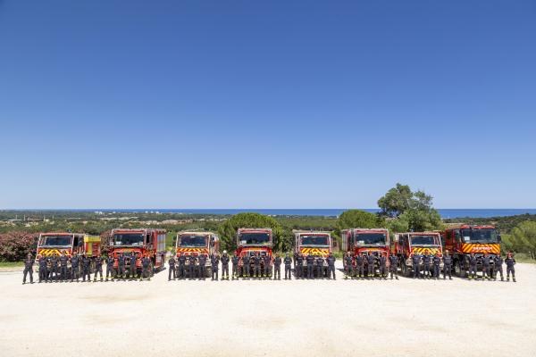
Unia Europejska
1 min czytania
EU ready for summer wildfires
This summer, the EU is deploying a record number of firefighters, aircraft and emergency experts to help protect lives, homes and nature.
Без рейтингу0 коментарів1 хв
Czytaj artykuł→
Dane i statystyki
1 min czytania
EDUC_UOE_ENRS10 - "Dataset: updated data"
Pupils enrolled in vocational upper secondary and post-secondary non-tertiary education by education level, sex and field of education
Без рейтингу0 коментарів1 хв
Czytaj artykuł→
Dane i statystyki
1 min czytania
EDUC_UOE_ENRA31 - "Dataset: updated data"
Students enrolled in STEM education fields - per thousand of population aged 20-29
Без рейтингу0 коментарів1 хв
Czytaj artykuł→